Tianyi Sensor IOT Technology Co., Ltd
Sales Manager:Ms. Emily Wang
Cel,Whatsapp,Wechat:+86 15898932201
Email:info@fengtutec.com
Add:No. 155 Optoelectronic Industry Accelerator, Gaoxin District, Weifang, Shandong, China


Sales Manager:Ms. Emily Wang
Cel,Whatsapp,Wechat:+86 15898932201
Email:info@fengtutec.com
Add:No. 155 Optoelectronic Industry Accelerator, Gaoxin District, Weifang, Shandong, China
Model:FT-DZ1
Brand:tianyi
1.Geological disaster monitoring background
Geological disaster monitoring mainly includes displacement monitoring, crack monitoring, deep groundwater level monitoring, soil moisture content, rainfall, etc.Geological disasters come from catastrophic damage to the geological environment by natural and man-made geological effects, mainly including collapses, landslides, mudslides, ground collapses and ground cracks.my country has complex and diverse geological disasters and frequent disasters, making it one of the most serious geological disasters in the world.In recent years, research on landslide and mudslide disasters has been the focus of industry research.In order to enhance the awareness of disaster prevention and reduction in the whole society, reduce casualties, maintain social stability and normal production and living order, improve people's quality of life, promote the economic construction in areas with serious geological disasters and the comprehensive development of various social undertakings, and enable the people to live and work in peace and contentment, it has become an urgent task to do a good job in geological disaster warning and forecasting.
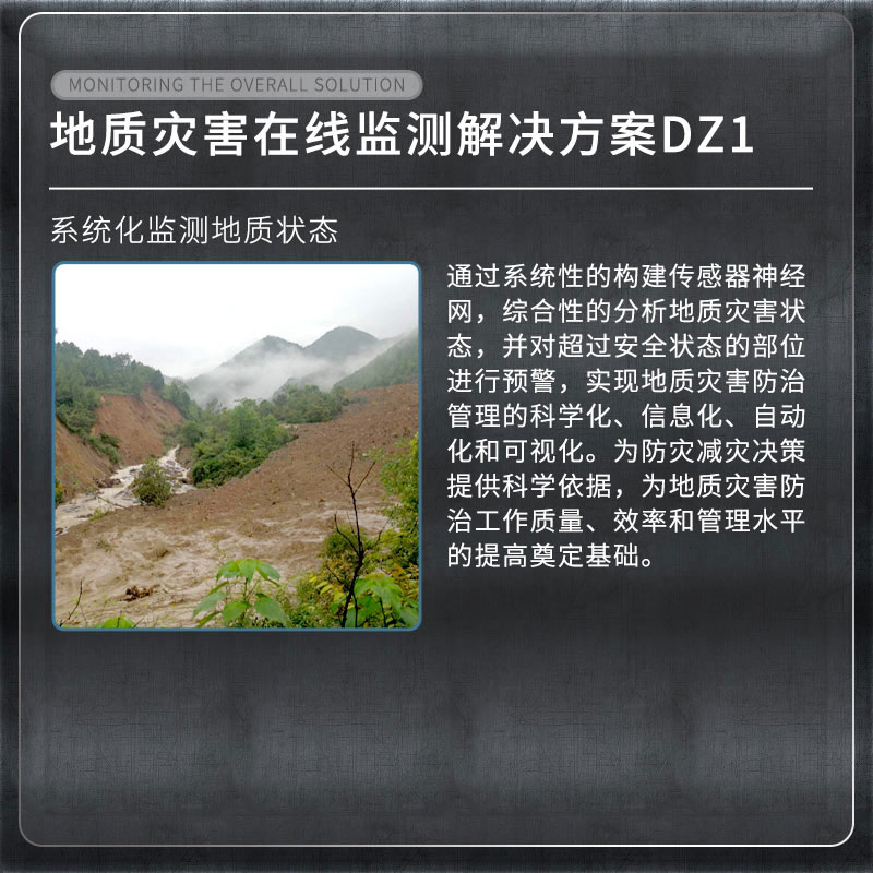
2.Overview of Geological disaster monitoring system
As a pioneer in industry monitoring, our company is the first to combine structural health monitoring with Internet of Things, cloud computing and other technologies.By systematically building sensor neural networks, comprehensively analyzing geological disaster status, and early warning of parts that exceed the safety status, so as to achieve scientific, informatized, automated and visualization of geological disaster prevention and control management.Provide scientific basis for disaster prevention and mitigation decisions, and lay the foundation for improving the quality, efficiency and management level of geological disaster prevention and control work.
3.List of Geological Disaster Monitoring Monitoring Projects
| Monitoring items | Device name |
| Surface displacement monitoring | Integrated GNSS monitoring system |
| Crack monitoring | Integrated surface displacement monitoring system |
| Deep displacement monitoring | Integrated deep displacement monitoring system |
| Groundwater level monitoring | Integrated pore water pressure monitoring system |
| Soil moisture content | Integrated soil temperature and humidity monitoring system |
| Rainfall | Integrated rainfall monitoring system |
| Video surveillance | Integrated video surveillance system |
| Mud level | Sludge level monitor |
4.Geological disaster monitoring basis
"Technical Specifications for Geological Disaster Monitoring DB11∕T 1677-2019"
"Geological Disaster Control Engineering Construction Safety Monitoring Specification T∕CAGHP 044-2018"
"Specifications on Monitoring of Collapse, Landslide and Mudslides"
"Technical Specifications for Groundwater Environmental Monitoring HJ/T164-2004"
"Geological Disaster Prevention and Control Engineering Survey Standard DB50∕143-2003"
5.Geological disaster monitoring implementation function
1.Through the automated monitoring platform, help management units realize geological information security monitoring and process management, and no longer be affected by the weather.Once an early warning occurs at any location on the scene, you can grasp the on-site situation through video monitoring, and take different alarm methods according to the warning level, and take emergency plan measures in a timely manner in combination with the relevant responsible units to evacuate the crowds, transfer in a timely manner to reduce accidents and disasters.
2.Achieve multi-level early warning and alarm mechanism from provinces, cities, counties and townships, provide emergency plans after early warning, and realize integrated disaster monitoring, early warning and response.Real-time long-term automated monitoring to prevent major landslides and mudslides and other geological disasters, reduce economic losses, and maintain social stability.
3D Ultrasonic Anemometer can measure the horizontal and vertical wind speed and direction values in three-dimensional space at high frequency, providing accurate and real-time data support for various industries.The working principle of this sensor is based on the propagation characteristics of ultr...
The Automatic Soil Monitoring System is a common device in modern precision agriculture and ecological environment monitoring. It provides reliable data for farmland irrigation, drought warning, and scientific research by measuring key parameters such as soil moisture, temperature, and electrical co...
High-standard farmland refers to high-yield and stable-yield farmland constructed through land consolidation, soil improvement, irrigation system development, and other measures. The key lies in "precision management" and "efficient output." Compared to ordinary farmland, high-st...
TianYi® EL Detector [Model: FT-EL1] Partial Parameters:Detectable Defect Types: Cracks, broken cells, fragments, broken grids, black core, poor soldering, process contamination, low-efficiency cells, black edge, over-firing, over-etching, perforations.Camera: 20-megapixel; Resolution: 4...


 Get a Free Quote
 Skype
Skype
 whatsapp
 mail
mail