Tianyi Sensor IOT Technology Co., Ltd
Sales Manager:Ms. Emily Wang
Cel,Whatsapp,Wechat:+86 15898932201
Email:info@fengtutec.com
Add:No. 155 Optoelectronic Industry Accelerator, Gaoxin District, Weifang, Shandong, China


Sales Manager:Ms. Emily Wang
Cel,Whatsapp,Wechat:+86 15898932201
Email:info@fengtutec.com
Add:No. 155 Optoelectronic Industry Accelerator, Gaoxin District, Weifang, Shandong, China
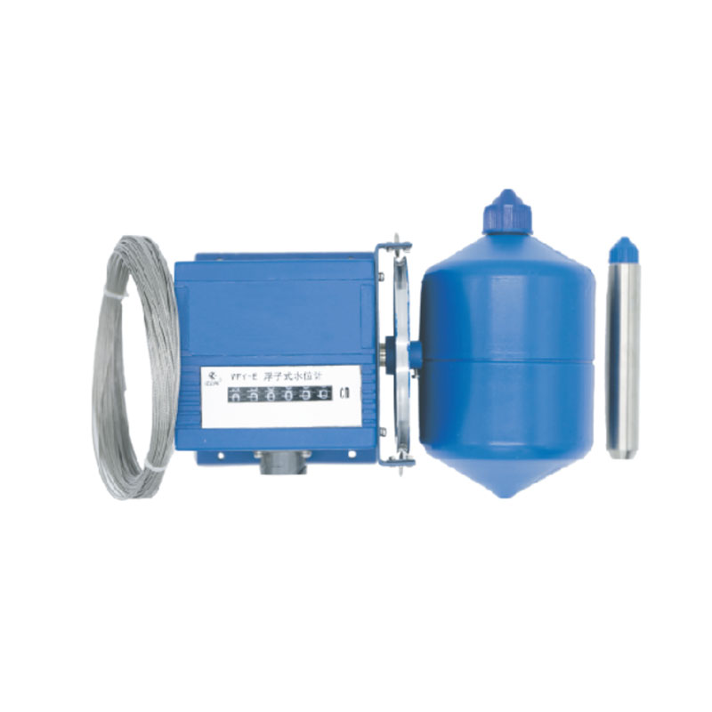
Model:FT-FW1
Brand:tianyi
1.Introduction to Float water level gauge product
Float water level gauge can display the actual water level in the tank and is a level measurement system suitable for non-pressure tanks/containers.Float water level gauge is a digital sensor integrating mechanical and electrical technology.By converting the angular displacement of the output shaft into a corresponding digital quantity, the measured liquid level height can be measured with high accuracy and the absolute position can be confirmed.It has power-off memory function.
Its working principle is: the water level sensor measuring wheel is installed on the encoder input shaft, the wire rope is connected to one end and the heavy hammer at the other end, and the wire rope is wound on the measuring wheel.When the liquid level changes, the float rises and falls with the change of the liquid level.The wire rope drives the measuring wheel to rotate, and the encoder outputs the corresponding real-time water level value.
The sensor has a reasonable structure, strong anti-interference ability, high resolution, large range, long life, and has signal tracking and memory function after power failure.It can be used for liquid level measurement for a long time and can ensure stable and reliable performance.
Widely applicable to the measurement of surface water or groundwater surface water such as rivers, lakes, reservoirs, ship locks, reservoirs, hydropower stations, hydrological stations, water plants, petrochemicals and other surface water.
2.Float water level gauge technical parameters
1.Basic parameters
Measurement range: 0-5, 10, 20, 40, 80 meters as required;
Water level variability: <100 cm/min
Resolution: 1cm
Water level wheel start torque: <100g·cm (0.0098N·m)
Measurement accuracy: ≤±2cm or 0.2%F·S
Monitor: Decimal mechanical counter
2.Mechanical parameters
Working circumference of water level wheel: 32cm
Measuring cable: Φ0.8mm plastic-clad stainless steel cable
Float diameter: 10cm
3.Electrical parameters
Output form: contact on and off output contact resistance: ≤0.5Ω; insulation resistance: ≥10MΩ
4.Communication interface (optional)
RS485 interface (MODBUS-RTU protocol);
Gray code output; 4-20mA current analog output;
5.Usage environment
Ambient temperature: -25℃~85℃
Relative humidity; <95% (40℃)
Size: 132×132×115
Reliability indicator: MTBF ≥25000 hours under normal maintenance conditions of the instrument
Power supply voltage: 12-24VDC (Grey code output is not required)
3.Working principle of Float water level gauge
Instrument structure and working principle:
This instrument consists of floats, wire ropes, heavy hammers, measuring wheels, sensors, brackets, output sockets, etc.
The working principle is: the instrument uses a float to sense water level changes.In the working state, the float, the heavy hammer and the wire rope are firmly connected, and the wire rope is suspended in the "V"-shaped groove of the water level wheel.The balance hammer plays a role in tightening the wire rope and balancing.Adjusting the counterweight of the float can make the float work on the normal water line.With the water level unchanged, the forces on both sides of the float and the balance hammer are balanced.When the water level rises, the float generates upward buoyancy, causing the balance hammer to pull the wire rope to drive the water level wheel to rotate clockwise, and the display reading of the water level sensor increases; when the water level drops, the float sinks, and the pulling the wire rope to drive the water level wheel to rotate counterclockwise, and the display reading of the water level sensor decreases.
In this series of instruments, the water level wheel of the mechanical water level sensor measures circumference of 32 cm, and the water level wheel is coaxially coupled to the sensor.Every time the water level wheel rotates, the sensor also rotates, and outputs the corresponding 32 sets of digital encodings.When the water level rises or falls, the sensor rotates at a certain angle, and the sensor synchronizes to output a corresponding set of digital codes (binary loop codes, also known as Gray codes).Instruments of different ranges can output 1024 to 8192 different sets of codes, which can be used to measure the water level magnitude of 10 to 80 meters.
The encoded signal can be transmitted to the electrical display or computer in the observation room through a multi-core cable connected to the instrument socket for observation, recording or data processing; the water level meter equipped with the RS485 digital communication interface can be directly connected to the communication machine and computer, forming a hydrological automatic reporting system and a water satellite telemetry system.
The instrument's built-in RS485 digital communication interface (optional) has site selection and gate functions, and can transmit information from a long distance in a two-wire system.It can drive or receive 31 water level (or gate) sensors on a pair of twisted pair signal lines to realize telemetry networking.
With the arrival of the rainy season, frequent rainfall is prone to triggering geological disasters such as floods and landslides, posing a huge threat to people's lives and property safety as well as social and economic development. In order to timely grasp the rainfall situation, scientificall...
The IV curve, or current-voltage curve, visually demonstrates the current output of a photovoltaic (PV) cell or module at different voltages. Through this curve, core parameters such as open-circuit voltage, short-circuit current, and maximum power point can be obtained. These parameters are crucial...
In the photovoltaic field, the I-V Curve Tracer is a core device used to measure and evaluate the electrical performance of solar cells and modules. The "IV" in its name stands for Current-Voltage. This instrument accurately plots the volt-ampere characteristic curve of the measured object...
In the solar energy industry, the quality of photovoltaic (PV) modules affects their power generation efficiency, and the EL detector is an important tool for inspecting the quality of PV modules.The EL detector works based on the principle of electroluminescence. When a forward voltage is applied t...


 Get a Free Quote
 Skype
Skype
 whatsapp
 mail
mail