Tianyi Sensor IOT Technology Co., Ltd
Sales Manager:Ms. Emily Wang
Cel,Whatsapp,Wechat:+86 15898932201
Email:info@fengtutec.com
Add:No. 155 Optoelectronic Industry Accelerator, Gaoxin District, Weifang, Shandong, China


Sales Manager:Ms. Emily Wang
Cel,Whatsapp,Wechat:+86 15898932201
Email:info@fengtutec.com
Add:No. 155 Optoelectronic Industry Accelerator, Gaoxin District, Weifang, Shandong, China
time:2025-03-12 14:11:31 source:Weather Station viewed:345 time
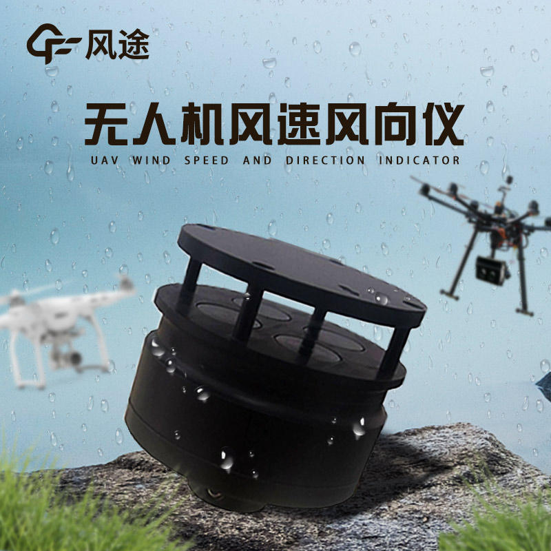
Anemometer for drones, the ultrasonic anemometer is a high - precision meteorological monitoring device designed based on the principle of ultrasonic resonance. It is specifically developed for the low - altitude environmental monitoring needs of small drones and unmanned platforms. Its core technology emits ultrasonic pulses in different directions and measures the time difference or frequency difference of the sound waves during downwind and upwind propagation. Combined with the built - in algorithm, it can analyze wind speed and wind direction data in real - time. Compared with traditional mechanical anemometers, this device completely abandons vulnerable components such as wind cups and propellers and adopts an all - solid - state structure design, effectively solving problems such as mechanical wear, starting wind speed limitations (capable of measuring zero wind speed), and low - temperature icing, and improving long - term stability and environmental adaptability.
The instrument is equipped with a high - strength ABS engineering plastic housing with a diameter of only 46mm and a weight of 56g, combining compactness and durability. It is internally equipped with a low - power chipset, supporting a wide voltage supply of 5 - 30V, and the standby current is as low as 15mA (12V), significantly extending the endurance of the drone. In terms of core performance, the wind speed measurement range covers 0 - 60m/s with an accuracy of ±3%; the wind direction detection range is 0 - 359° with an accuracy of ±3° and a resolution of 1°, which can accurately capture instantaneous wind field changes.
The manufacturer provides two installation modes: top - mounted and bottom - inverted hoisting. Top - mounting can minimize the interference of the fuselage air flow and ensure data accuracy; bottom - mounting is suitable for scenarios with limited space or multi - sensor collaborative operations, expanding the compatibility of the drone platform. The data interface adopts the RS485 standard and supports the ModBus/ASCII protocol, facilitating seamless docking with the flight control system and real - time data transmission to the cloud or local monitoring platform.
The Micro water quality station is a highly integrated professional device that combines various functions such as sensor technology, data collection and processing systems, and communication modules. Its working principle is based on the monitoring of various parameters in the water body by differe...
A soil moisture monitoring system is a comprehensive station that conducts real-time monitoring of soil moisture and related environmental parameters. Equipped with high-precision sensors, it adopts technologies such as Frequency Domain Reflectometry (FDR) and Time Domain Reflectometry (TDR) to accu...
Total Nitrogen Analyzer utilizes the resorcinol method and photoelectric quantitative technology. Its integrated design allows for rapid sampling and testing, boasts strong anti-interference capabilities, and enables real-time monitoring of total nitrogen content in water. It is widely used in...
Traditional meteorological monitoring stations are relatively fixed in distribution, making it difficult to comprehensively cover complex terrains and vast areas. There are also certain limitations in the timeliness of data. Mobile meteorological monitoring can flexibly penetrate different regions t...


 Skype
Skype
 whatsapp
 mail
mail