Tianyi Sensor IOT Technology Co., Ltd
Sales Manager:Ms. Emily Wang
Cel,Whatsapp,Wechat:+86 15898932201
Email:info@fengtutec.com
Add:No. 155 Optoelectronic Industry Accelerator, Gaoxin District, Weifang, Shandong, China


Sales Manager:Ms. Emily Wang
Cel,Whatsapp,Wechat:+86 15898932201
Email:info@fengtutec.com
Add:No. 155 Optoelectronic Industry Accelerator, Gaoxin District, Weifang, Shandong, China
Model:FT-F1H
Brand:tianyi
1、3D Anemometer for Unmanned Aerial Vehicles Product Introduction
3D Anemometer for Unmanned Aerial Vehicles is a high-precision three-dimensional ultrasonic anemometer that measures wind speeds up to 50 meters per second and can be used for atmospheric monitoring.3D Anemometer for Unmanned Aerial Vehicles features a compact design (measuring path of only 35 mm) and a lightweight construction (114 grams). Despite its small size, it is a powerful and highly accurate wind measurement sensor used for atmospheric monitoring, weather reporting, and environmental airflow system research, providing data on wind speed, wind direction, inclination, electronic compass, and BeiDou navigation system.
3D Anemometer for Unmanned Aerial Vehicles provides precise three-dimensional wind measurement data of airflow. Data output can be customized according to user requirements.
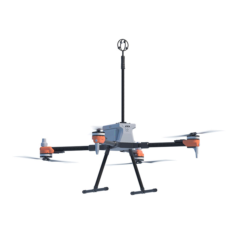
The small size and lightweight design of the 3D Anemometer for Unmanned Aerial Vehicles make it a perfect choice for Unmanned Aircraft Systems (UAS). The absence of moving parts eliminates maintenance issues, allowing it to be placed on fixed or mobile platforms for real-time three-dimensional airflow measurements in natural environments.
2、3D Anemometer for Unmanned Aerial Vehicles Application Areas
Atmospheric detection and scientific research
U, V, W vector output
UAV-based high-altitude airflow monitoring system
Emergency rescue and special surface air turbulence monitoring
Monitoring of upward airflow on slopes for weather modification
3、3D Anemometer for Unmanned Aerial Vehicles Technical Parameters
| Wind speed | Measurement range | 0-50m/s |
| Precision | ±2% | |
| Resolution | 0.1m/s | |
| Wind direction | Measurement range (U/V) | 0-359° |
| Measurement range (W) | ±60° | |
| Precision | ±3° | |
| Resolution | 1° | |
| Ultrasonic output frequency | 1Hz (standard output); 2Hz, 5Hz, 10Hz (optional) | |
| Unit of measurement | m/s,knots,mph,kph,ft/min | |
| Digital/analog output interface | RS232/RS485 (one of them) | |
| Communication baud rate | 4800-19200 | |
| Protection level | IP65 | |
| Working temperature | -40℃-+70℃ | |
| Electromagnetic shielding | Meet EN61000-6-2 standard | |
| Power requirements and consumption | DC9-30V (30mA@12V) | |
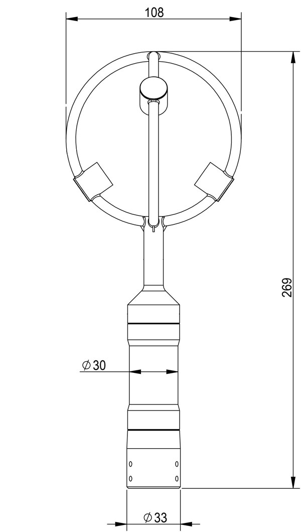
| Dimensions/weight | Φ108×269mm/114g | |
| Materials | Black resin | |
4、3D Anemometer for Unmanned Aerial Vehicles Product dimensions diagram
This fully automated online hydrological monitoring device, based on K-band planar radar technology, can simultaneously measure water level, flow velocity, flow rate, and rainfall. Employing a non-contact measurement method, it is unaffected by silt and sewage corrosion. Its built-in intellige...
Underwater Side-Scan Sonar utilizes the underwater propagation characteristics of sound waves to perform underwater detection through electro-acoustic conversion and information processing. Equipped with a 7-inch high-brightness IPS screen, it supports independent control of four- or six-way s...
Precision Snow/Rain Gauge is capable of monitoring all types of precipitation—including liquid, solid, and mixed solid-liquid phases. It features a real-time precipitation intensity measurement range of 6 to 1800 mm/h and a cumulative precipitation range of 0.2 to 1500 mm, with an RS485 inter...
In the development process of smart agriculture, various advanced technologies and equipment are continuously updating agricultural production modes. As a core tool, the soil moisture monitoring station is deeply integrating into the modern agricultural production system.Soil moisture, i.e., the soi...


 Get a Free Quote
 Skype
Skype
 whatsapp
 mail
mail