Tianyi Sensor IOT Technology Co., Ltd
Sales Manager:Ms. Emily Wang
Cel,Whatsapp,Wechat:+86 15898932201
Email:info@fengtutec.com
Add:No. 155 Optoelectronic Industry Accelerator, Gaoxin District, Weifang, Shandong, China


Sales Manager:Ms. Emily Wang
Cel,Whatsapp,Wechat:+86 15898932201
Email:info@fengtutec.com
Add:No. 155 Optoelectronic Industry Accelerator, Gaoxin District, Weifang, Shandong, China
time:2025-07-25 08:52:53 source:Weather Station viewed:341 time
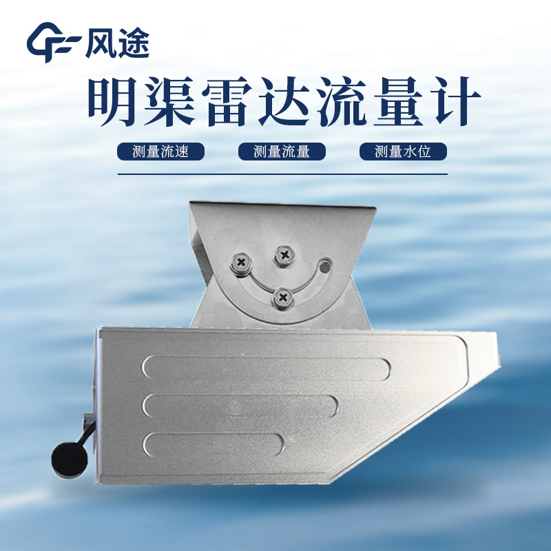
Every flood season, heavy rainfall occurs frequently, causing water levels in rivers and lakes to rise rapidly, and the risk of flood disasters increases significantly. During such a special period, the Radar Current Meter, as a professional hydrological monitoring device, becomes an important tool for safeguarding flood season safety.
The Radar Current Meter is an automated device that integrates water level, flow velocity, and flow rate monitoring. Its water level measurement adopts high-frequency radar technology, which emits electromagnetic waves of a specific frequency to the water surface, receives the reflected signal, calculates the propagation time difference, and combines it with the installation height to obtain real-time water level data. This measurement method is not affected by water surface fluctuations, floating objects, or water composition, and the measurement accuracy can be controlled at the centimeter level, enabling accurate recording of every change in water level.
The flow velocity measurement is based on the Doppler principle. When the radar waves emitted by the device irradiate the suspended particles in the water flow, the frequency of the reflected waves will shift due to the movement of the water flow. By analyzing the frequency shift and the angle between the beam and the water flow, the device can directly calculate the water flow velocity.
By combining real-time water level and flow velocity data, the device can output flow rate values synchronously through a built-in flow calculation formula or a preset water level-flow relationship model, achieving comprehensive monitoring of water dynamics.
In flood situations caused by heavy rainfall, it adopts a non-contact measurement design, eliminating the need to immerse the sensor in water. This fundamentally avoids problems such as water corrosion and sediment blockage, making it suitable for use in complex water areas with a large number of floating objects or high sediment content. Even in severe weather conditions such as heavy rain and strong winds, the anti-interference ability of radar signals can ensure the continuity of data collection, without interrupting monitoring due to weather changes.
The device has low power consumption and can operate in the field for long-term unattended operation when combined with a solar power supply system. The built-in data storage module can record historical monitoring data and supports remote transmission function, which can send real-time water regime data to the flood control command center. The installation process does not require large-scale civil construction and can be fixed on existing structures such as bridges and dams through brackets, enabling rapid deployment of monitoring points.
In actual flood control work, the continuous monitoring data provided by these devices is a key basis for decision-making. When heavy rainfall causes the water level to rise rapidly, the device can detect the water level rise and flow velocity changes in real-time, providing data support for judging the evolution trend of floods and early warning of the arrival time of floods.
In the fields of meteorology, environmental monitoring, agriculture, hydrology, transportation, and wind power generation, obtaining high-precision, high-time-resolution meteorological data for small-scale (microscale) areas is crucial. Traditional meteorological observation stations are usually lar...
Displacement monitor device utilizes harmless laser technology to accurately detect minute displacements in building structures such as walls and beams after disasters like earthquakes and explosions. By identifying even the slightest unstable movement, this equipment provides timely warnings...
The buoy-type online water quality monitoring system is a modern water body monitoring method. As an automated device for long-term and real-time monitoring of water quality, it is widely used in environmental monitoring of various water areas such as rivers, lakes, oceans, reservoirs, and aquacultu...
An air quality monitoring station is an unmanned environmental monitoring device that integrates data collection, storage, transmission, and management. Its core advantage lies in its ability to conduct high-precision, real-time monitoring of various pollutants. The system can provide data on parame...


 Skype
Skype
 whatsapp
 mail
mail