Tianyi Sensor IOT Technology Co., Ltd
Sales Manager:Ms. Emily Wang
Cel,Whatsapp,Wechat:+86 15898932201
Email:info@fengtutec.com
Add:No. 155 Optoelectronic Industry Accelerator, Gaoxin District, Weifang, Shandong, China


Sales Manager:Ms. Emily Wang
Cel,Whatsapp,Wechat:+86 15898932201
Email:info@fengtutec.com
Add:No. 155 Optoelectronic Industry Accelerator, Gaoxin District, Weifang, Shandong, China
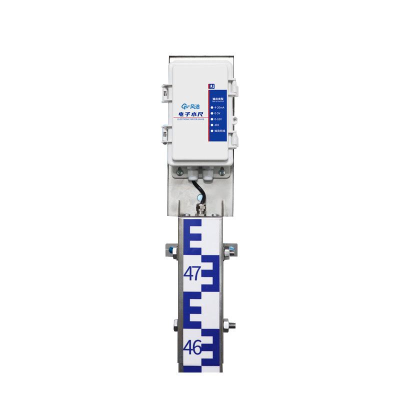
Model:FT-SC24
Brand:tianyi
Water Level Gauge is able to transmit data over the Internet, allowing users to remotely monitor water levels in streams, rivers, and other bodies of water.Water Level Gauge equipment composition: host, water ruler section, collector, power supply system, vertical pole
Water Level Gauge working principle: Using the principle of weak conductivity of water, using advanced processor chips as controllers, water level data is obtained through measurement electrodes, and transmitted through CPU digital encoding, indexing, sampling, and digital processing. Then, wired or wireless communication technology is used to send the water level data to the monitoring center or software, giving full play to the role of real-time monitoring and early warning of water level.
Power supply method: solar power supply, 30W, 20AH
Transmission method: 2G wireless transmission, optional 4G
Installation method: wall-mounted
Equipment accuracy 1cm (full range and other accuracy)
Resolution: 1cm
Unit section specification: 80cm
Measurement length: 80cm*3
Communication interface: RS485 is standard, and can be equipped with 4G, 4-20ma, 0-5v, 0-10v
Parameter configuration: Configuration tool configures specific parameters
Working mode: air height mode, water depth mode, tilt mode
Maximum power consumption: The maximum power consumption of the host is 1W, and the maximum power consumption of the water ruler is 0.05W
Control card: RS485 has a one-way relay output by default, and can be associated with any alarm output or used for water level upper and lower limit control.
Installation punching size: 86.2mm
Installation hole diameter: 10mm
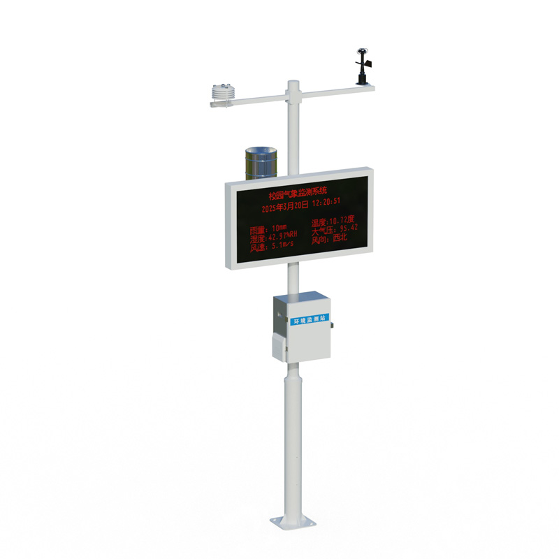
As meteorological monitoring needs become increasingly diverse, traditional meteorological equipment faces challenges in installation convenience, data comprehensiveness, and environmental adaptability. Conventional miniature weather instruments often suffer from measurement errors caused by sensor...
Here's a little bit of knowledge: Bridges actually freeze more easily than road surfaces.Why is that?From the perspective of heat dissipation, the temperature difference between a bridge deck and an ordinary road surface is quite understandable. The road surface is directly built on the ground,...
In transportation, high-speed railways and road transport are significantly affected by meteorological conditions. In severe weather such as heavy rain, snowstorms, heavy fog, or strong winds, road surfaces become slippery, visibility drops sharply, and high-speed railway tracks may even freeze. All...
In terms of application value, the popularization of integrated dust monitoring sensors like the FT-WQX8 is transforming traditional environmental monitoring models. In the past, single-parameter monitoring devices required separate deployment and maintenance. Not only did this result in high initia...


 Get a Free Quote
 Skype
Skype
 whatsapp
 mail
mail