Tianyi Sensor IOT Technology Co., Ltd
Sales Manager:Ms. Emily Wang
Cel,Whatsapp,Wechat:+86 15898932201
Email:info@fengtutec.com
Add:No. 155 Optoelectronic Industry Accelerator, Gaoxin District, Weifang, Shandong, China


Sales Manager:Ms. Emily Wang
Cel,Whatsapp,Wechat:+86 15898932201
Email:info@fengtutec.com
Add:No. 155 Optoelectronic Industry Accelerator, Gaoxin District, Weifang, Shandong, China
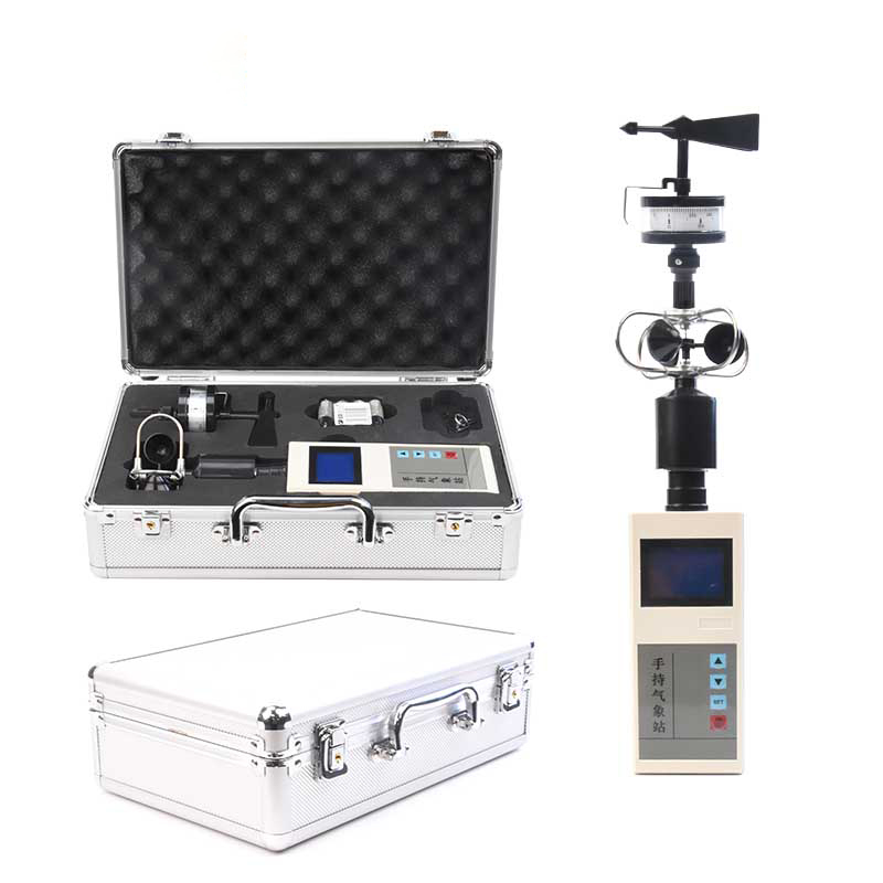
Model:FT-SQ2
Brand:tianyi
1.Introduction to Handheld Anemometer Products
Handheld Anemometer is a portable wind speed measurement tool that can measure wind speed with high accuracy and reliability and display the wind speed data on the display.
Handheld Anemometer is a movable meteorological observation instrument that is easy to carry, simple to operate, and integrates multiple meteorological elements.The system uses precision sensors and smart chips, which can accurately measure the two meteorological elements of wind direction and wind speed at the same time.The built-in large-capacity FLASH storage chip can store meteorological data for at least one year; it is a universal USB communication interface, which connects to the USB disk to export data, which facilitates users' further processing and analysis of meteorological data.
Handheld Anemometer can be widely used in meteorological, environmental protection, airports, agriculture and forestry, hydrology, military, warehousing, scientific research and other fields.
2.Functional features of Handheld Anemometer
2.1-inch screen LCD display temperature and wind speed;
A specially made wind dial (16 orientations) and pointers are used to indicate real-time wind direction;
Large-capacity data storage, up to 40,000 meteorological data can be stored (data recording interval can be set between 1 and 60 minutes);
Universal USB communication interface, convenient for USB data download;
Only three No.5 dry batteries are required to be powered; low-power design, long-term standby;
The structure is scientific and reasonable, and is easy to carry.
3.Handheld Anemometer technical parameters
| Meteorological parameters | Measurement elements | Measurement range | Accuracy | Resolution | unit |
| Wind speed | 0~30 | ±0.3 | 0.01 | m/s | |
| wind direction | 16 directions | ±1 azimuth | 1 position | position | |
| power supply | No.5 dry battery (3 sections) | ||||
| communication | USB | ||||
| storage | 40,000 data | ||||
| Host size | 160mm×70mm×28mm | ||||
| Overall machine size | 405mm×100mm×100mm | ||||
| weight | About 0.5Kg | ||||
| Working environment | -20℃~80℃; 5%RH~95%RH | ||||
4.Precautions for using Handheld Anemometer
1.It is recommended to clean up the data storage every time the computer needs to start, to prevent the large amount of data when exporting the currently required data, resulting in too long time.
2.It is recommended to export the data content in the weather station in a timely manner after use.
3.Please read this manual carefully before use to ensure that the sensor must be inserted into the corresponding sensor interface and the battery direction is correct;
4.When the battery level is insufficient on the instrument, please change the battery in time to prevent the battery from leaking and damaging the instrument;
5.Prevent chemical reagents, oils, dust, etc.from directly invading the sensor.Do not use it for a long time under condensation or extreme temperature environments.Do not cause cold or hot impact;
6.The instrument is a precision device.Users should not disassemble it by themselves when using it to avoid damaging the product;
7.Please save the verification certificate and certificate of conformity and return with the product during maintenance.
In the complex and unpredictable rescue environment, firefighters often face numerous challenges. Tasks such as underwater rescue and the inspection of waterlogged areas at fire scenes have become difficult aspects of rescue work due to the interference of water bodies and insufficient light. The em...
Against the backdrop of rapid industrialization, industrial parks—core hubs for industrial agglomeration—face prominent pollution discharge issues. These issues are characterized by complex compositions, diverse types, and high emission intensity. Among them, industrial clusters and parks involvin...
The Portable Visibility Monitor employs the forward scattering method to measure the total extinction coefficient of the air, offering a visibility range of up to 20 kilometers with a resolution of 1 meter. Compact and lightweight, the device is ready for immediate use upon power-up. It is wid...
Traditional air quality monitoring stations (national and provincial control points) use extremely sophisticated and expensive equipment, resulting in very high construction and operational costs. Consequently, a city typically has only a handful of such stations. Due to the limited number of statio...


 Get a Free Quote
 Skype
Skype
 whatsapp
 mail
mail