Tianyi Sensor IOT Technology Co., Ltd
Sales Manager:Ms. Emily Wang
Cel,Whatsapp,Wechat:+86 15898932201
Email:info@fengtutec.com
Add:No. 155 Optoelectronic Industry Accelerator, Gaoxin District, Weifang, Shandong, China


Sales Manager:Ms. Emily Wang
Cel,Whatsapp,Wechat:+86 15898932201
Email:info@fengtutec.com
Add:No. 155 Optoelectronic Industry Accelerator, Gaoxin District, Weifang, Shandong, China
time:2026-04-16 13:28:10 source:Weather Station viewed:359 time
Radar water level gauges utilize K-band planar radar technology to perform non-contact measurements of water levels and rainfall. With a measurement range of 0.1 to 40 meters, an accuracy of ±5 mm, and a resolution of 1 mm, these devices are widely deployed in water conservancy monitoring fields, including river channels, irrigation canals, underground pipe networks, and flood warning systems.
The radar water level gauge is a fully automated online hydrological monitoring system based on microwave technology. By employing K-band planar radar technology, it measures water levels and rainfall in a non-contact manner. The device utilizes Frequency Modulated Continuous Wave (FMCW) radar technology: the radar antenna emits high-frequency microwave pulses toward the water surface and receives the reflected echo signals. By calculating the time difference between transmission and reception, the device determines the distance from the antenna to the water surface, thereby deriving the water level height. The measurement process remains unaffected by factors such as temperature, sediment, river pollutants, or surface debris, ensuring stable operation even during rain, snow, fog, or surface turbulence.
In terms of technical specifications, mainstream radar water level gauges feature a measurement range of 0.1 to 40 meters, an accuracy of ±5 mm, and a resolution of 1 mm. Data refresh rates can reach as fast as 40 ms, and the radar operates within the 80 GHz frequency band. Certain models also integrate rainfall monitoring capabilities, offering a rainfall intensity measurement range of 0 to 4 mm/min with an accuracy of ±0.2 mm, thereby providing comprehensive data support for water resource management and flood warning systems. Regarding flow velocity measurement, the device covers a range of 0.15 to 15 m/s, with an accuracy of ±2% and a velocity resolution of 0.01 m/s. The device supports multiple communication interfaces—such as RS485 and 4–20 mA—and is compatible with the standard Modbus-RTU protocol, allowing data to be transmitted in real-time via 4G networks to a central monitoring platform.
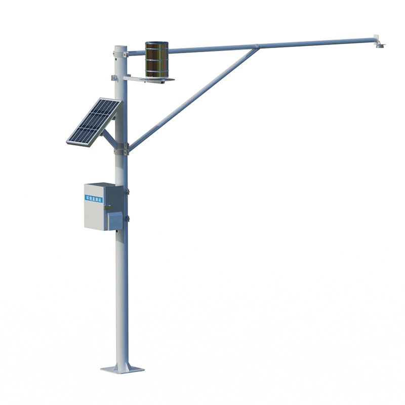
Radar water level gauges are extensively utilized for measuring water levels, flow rates, and rainfall in diverse environments, including rivers, lakes, tidal zones, reservoir sluice gates, underground pipe networks, and irrigation channels. They are also applicable to auxiliary water management operations, such as urban water supply and sewage monitoring. Regarding flood control early warning systems, Xinwu District has deployed 194 sets of intelligent radar liquid-level monitoring stations and 159 sets of intelligent radar pressure-level monitors for monitoring stormwater drainage manholes. These systems transform key indicators—such as river water levels, drainage network operational status, and water accumulation at flood-prone spots—into dynamic data that can be monitored in real time, thereby enabling risk prediction and tiered early warning alerts. The lightweight radar water-level gauge, independently developed by the Ningmeng Hydrological Bureau, has been successfully commissioned at the Hasuhai Reservoir. Requiring only 20 minutes to install, the device reduces the data update interval from once every few hours (typical of manual observation) to once every few minutes, achieving round-the-clock, real-time monitoring of reservoir water levels and automated flood reporting. Hikvision’s integrated "radar-gun-and-dome" water-level monitoring unit combines video-based level measurement with AI algorithms; enhanced by filtering algorithms, it can correct errors caused by water surface fluctuations in real time, achieving high-precision water-level measurements with an accuracy of ±1 mm and a maximum detection range of up to 100 meters. This solution has already been successfully deployed across more than 1,700 irrigation districts.
PV Weather Station monitors elements such as solar radiation and temperature and humidity, providing data support for the operation of photovoltaic power plants....
As meteorological monitoring needs become increasingly diverse, traditional meteorological equipment faces challenges in installation convenience, data comprehensiveness, and environmental adaptability. Conventional miniature weather instruments often suffer from measurement errors caused by sensor...
As a densely - populated public place, the air quality in scenic spots directly affects the tourist experience and ecological value. The negative oxygen ion concentration, as a core indicator for measuring air quality, has made its monitoring system a standard configuration in the construction of sm...
In the photovoltaic industry, requirements for module quality and reliability are becoming increasingly stringent. Traditional inspection methods cannot effectively identify internal defects, making EL (Electroluminescence) defect detection technology an indispensable quality control tool in photovo...


 Skype
Skype
 whatsapp
 mail
mail