Tianyi Sensor IOT Technology Co., Ltd
Sales Manager:Ms. Emily Wang
Cel,Whatsapp,Wechat:+86 15898932201
Email:info@fengtutec.com
Add:No. 155 Optoelectronic Industry Accelerator, Gaoxin District, Weifang, Shandong, China


Sales Manager:Ms. Emily Wang
Cel,Whatsapp,Wechat:+86 15898932201
Email:info@fengtutec.com
Add:No. 155 Optoelectronic Industry Accelerator, Gaoxin District, Weifang, Shandong, China
time:2025-07-17 08:50:40 source:Weather Station viewed:391 time
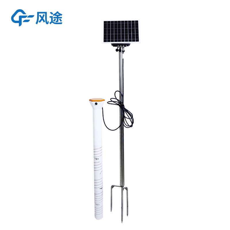
A soil moisture monitoring system is a comprehensive station that conducts real-time monitoring of soil moisture and related environmental parameters. Equipped with high-precision sensors, it adopts technologies such as Frequency Domain Reflectometry (FDR) and Time Domain Reflectometry (TDR) to accurately measure the moisture content of soil layers at different depths. It can also monitor indicators like soil temperature and field light intensity around the clock.
The data collector gathers and processes data from the sensors, and the transmission module sends the data to the cloud platform in real-time via a wireless communication network. Agricultural management departments and farmers can check the data at any time through a mobile app or computer terminal. The power supply system relies on solar panels and storage batteries to ensure continuous operation, and together with infrastructure such as brackets and protective devices, it forms a complete monitoring system.
In the farmland of large-scale growers, the dynamic changes of field moisture are clearly visible through the monitoring station. Farmers can set early warning thresholds according to the crop growth stage and soil type. When the monitored data is lower than the drought threshold, the system will promptly notify users via text messages, app push notifications, etc., and provide specific guidance such as "What is the soil moisture content? When is it necessary to water?" and "The soil has reached a drought state, and growth regulators need to be sprayed." Relying on intelligent early warning, farmers can predict drought risks in advance, arrange irrigation reasonably, improve the efficiency of water resource utilization, and prevent crop yield reduction due to drought.
In this way, the monitoring station is like a professional doctor. Traditional agriculture relies on experience for judgment, which easily leads to improper application of water and fertilizers. However, the monitoring station can obtain real-time data on soil moisture, temperature, electrical conductivity, pH value, etc., and provide comprehensive support in combination with environmental parameters. Agricultural management departments formulate fertilization and irrigation plans based on the data, realizing precise fertilization and irrigation, optimizing fertilization schedules, improving fertilizer utilization efficiency, and reducing the risk of non-point source pollution. It provides scientific guidance for increasing agricultural efficiency and ensuring farmers' harvests, just like prescribing "targeted drugs" for farmland, promoting grain yield increase.
Employing 24GHz Doppler radar technology, the radar rain gauge measures the falling velocity of raindrops through a small flat-panel radar module. It can distinguish between rain, snow, and hail, as well as rainfall intensity. With no moving parts and requiring no maintenance, it is suitable f...
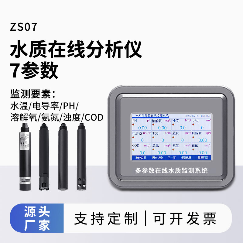
Water quality monitoring equipment, centered around sensors for water temperature, pH, dissolved oxygen, and turbidity, can collect and analyze water data in real time. This equipment is widely used in various water environment monitoring applications, including aquaculture, wastewater treatment, reservoirs, rivers, and drinking water sources....
The core of the Odor Online Monitor lies in simulating human olfactory perception, enabling simultaneous monitoring of multiple malodorous pollutants. It is particularly suitable for 24/7 continuous monitoring in environments such as landfill sites, chemical industrial parks, and wastewater treatmen...
20km Portable Visibility Detector device employs the forward scattering method to calculate current atmospheric visibility by measuring the total extinction coefficient of the air. This equipment can be deployed on highways, mountain roads, and other similar locations to provide real-time visibility information, assisting traffic management departments in adjusting speed limits and issuing warnings. It is widely used in emergency response, road traffic, and meteorological monitoring....


 Skype
Skype
 whatsapp
 mail
mail